Analysis of the recent anomalous torrential rain
in the Levant and Middle East in early November 2015
By Captain M.L. Chi-ti-tewan Devakul
During the end of October to the beginning of November 2015 the "rare" case had turned into "frequent". Two Cyclones first Chapala followed by Megh all in just about ten consecutive days anomalously and very rarely originated and gained their strength in the warm water of the Arabian Sea which were also likely to have been driven partly under much influence of the inter-connected El Nino 2015 and the condition of global warming.
Both of the Cyclones made their ways deep in to the Gulf of Aden yielded wider extremely low pressure areas which also finally connected to the extended low pressure trough up in the warm Red Sea. Certainly the Cyclones' destructive howling wind and torrential rain hit parts of the countries in their paths of direct affected areas.
And subsequently, at the beginning period of winter time for northern hemisphere regions, these low pressure conditions and troughs also further influenced and affected higher pressure air mass ridges by making cool and moist Westerly Polar Jet win filled in much stronger to the areas of east Mediterranean and the Middle East.
In the mean while the preceding warmer easterly and southerly winds from desert blew in and brought along hazy condition of high volumes of dust and sand accumulated in the atmosphere over the Middle East and the Levant. In conjunction, further more, the cool Westerly wind also picked up more high moisture air over the warm water of east Mediterranean.
Evidence and records show that, even more, when natural dust and/or haze was also present somewhere in the atmosphere of the Middle East natural total rainfalls seemed to increase. This was the result that dust and/or haze strongly caused clouds to become even more efficient natural precipitators by increasing the concentrations of ice nuclei in the air and / or by aiding the growth of cloud drops by collision and coalescence especially, in the favourable condition of a winter time rain around the 40° North latitudes.
The clashing of these perfect elements for rain resulted in much more occasional highly intense thunder-storm and torrential rain showers at some scattered spots in the Levant which have caused recent floods for example, in Iraq, Iran, Saudi Arabia, Yemen, Oman, Lebanon, Jordan, Israel, and in more countries in the Middle East.
In conclusion, it means that in some countries and regions affected by the anomaly and high variability of weather conditions some places can get heavy rain while some places nearby face drought and the conditions may swap in just a sudden as well.
Winter and rainy season can be shorter or even longer while dry seasons may extend or perhaps are in contrary. The matter of fact is that because of the situation of totally high variability in today's world weather patterns of anomalously shifting and changing conditions it could also possibly make the weather more or less precisely well predictable.
Good luck and all the best,
Captain Chititewan Devakul
http://rainmakings.blogspot.com
_______________________________________________________________________________________


On 9th Nov. 2015 Ashkelon city by the shore of east Meditteranean about 40 km. south of Tel Aviv, Israel was partly submerged by some hours of torrential rain, 92 mm. in 60 min., causing bad flooding situation ever. (The above two pictures)


And the above two pictures show almost the same thing happened partly in Amman, Jordan on 5th Nov. 2015 by early morning torrential rain for some hours at about 35 - 65 mm. in 60 min.


While Cyclone Chapala, rarely originated in the Arabian Sea was clearly seen progressing in to the Gulf of Aden, on 4th Nov. some cells of heavy rain reported could as well be seen by several of the weather radar images above, continuously through dawn and morning, over the Sea of Galilee and its northern water-shed areas in northern Israel.


On 4th and even heavier on 5th Nov. rain band could be obviously seen via all the satellite pictures above over the warm sea of east Mediterranean and across the Levant deep into Iraq. The result was some torrential rain which flooded parts of Amman, Jordan.


The Cyclone Chapala could be seen located where the Gulf of Aden meets the Red Sea.
Out in the Arabian Sea another Cyclone Megh was moving in.


Out in the Arabian Sea another Cyclone Megh was moving in.


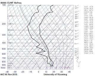
On 6th as well as 7th through 8th and 9th greater conditions of some precipitations are shown by the Skew-T upper air sounding datas which are also corresponding to satellite pictures and weather radar images. The Cyclone Megh is seen located in the Gulf of Aden
over the island of Socotra.

over the island of Socotra.


On 9th Nov. intensified cells of heavy rain could be seen over Ashkelon city in the morning
which yielded big flood ever.
which yielded big flood ever.
And below on the 10th Nov. high pressure filled in deep in to half of the Middle East and the sky had become clear.


Also once again a re-occurrence of low pressure spot in the Arabian Sea came back once more in a cycle of weather at the transitioning period before becoming full winter in the Levant.


The instability, once again the clashing of westerly cooler air mass and southerly warmer air mass with presence of dust and decent humidity, could be seen. The result of these good elements is certainly some middle and high altitude clouds, and some scattered thunder-storms and rain showers.
Out in the Arabian Sea, just southeast of the Gulf of Aden, and near the Horn of Africa also
once again a large spot of low pressure area could be seen as well.
Author: mlcdevakul@gmail.com
http://royalrainmaking.blogspot.com

The Mediterranean Climate Belt of the 40°N and 40°S


The instability, once again the clashing of westerly cooler air mass and southerly warmer air mass with presence of dust and decent humidity, could be seen. The result of these good elements is certainly some middle and high altitude clouds, and some scattered thunder-storms and rain showers.
Out in the Arabian Sea, just southeast of the Gulf of Aden, and near the Horn of Africa also
once again a large spot of low pressure area could be seen as well.
Author: mlcdevakul@gmail.com
http://royalrainmaking.blogspot.com
********************************
Here's an updated of the anomaly of weather for the year 2018, 2019, 2020.
October 2020:
Wow! 141 mm. of rain during the night of 15-16, 2020, Oct. alone in Nakorn-Ratchasima province!! Thailand which caused big flood. A real anomaly of the long forecasted La Niña condition in fact.
Certainly a transitioning time of the seasons where climate change could make it a little more severe in places as well as unreal otherwise pleasant!! in every part of the world.
Be cautious, be weather wise with good advance preparedness. Be safe.
Best wishes,
*****************
Now it's October once again!, soon a transitioning time of the seasons. Be weather wise with good advance preparedness. The anomaly of weather due to climate change has done so much huge damage in all aspects in some areas and regions of almost every part of the world especially during this period. Besides other places, here are some examples of how it so unexpectedly and unbelievably occurred in some desert countries of the Middle East where, in fact, water is in total scarcity.
Very similar to the anomaly of weather recorded in the web- blog posted herein of the disastrous floods in November 2015, here are what repeatedly happened in the Levant near the end of 2018 and the begining of 2019. It's almost unreal!
In the late October 2018,
"further heavy rain in parts of the Middle East has caused flash flooding in Kuwait and Jordan, where at least 12 people have lost their lives. Severe weather including record rainfall and flooding has affected parts of the Middle East since late October, 2018.
Heavy rains and subsequent flash flooding on 9 November 2018 left at least 12 people dead in central and southern areas of Jordan.
On 10 November, Minister of State for Media Affairs Jumana Ghunaimat said in a statement that the death toll of the flash floods has risen to 12 (seven in Madaba; 4 in the Dhab’a area of the Desert Highway (Jizah District, Amman Govenorate) and one in the southern governorate of Ma’an).
A total of 29 people were injured in the flash floods, including 8 Civil Defense and Public Security departments personnel. Emergency teams are are still searching for 14 missing people in Al-Jafr in Ma’an Governorate.
The floods also forced the evacuation of nearly 4,000 tourists from the ancient city of Petra, Ma’an Governorate, where floodwaters in some areas rose up to 4 metres according to state TV. Flash flooding also triggered a state of emergency in the port city of Aqaba.
The floods come just 2 weeks after 21 people died in flash floods in the Dead Sea region of the country."
For February 2019,
"flooding caused by heavy rain from late Wednesday 27 February led to numerous rescues and traffic disruptions in areas around Jerusalem. Strong winds also caused some damage.
Times of Israel said that around 136mm of rainfall hit Jerusalem on 28 February, equal to one-quarter of the city’s annual average rainfall. According to WMO, the Mean Total Rainfall for February in Jerusalem is 131.2mm.
The heavy rain led to flooding and multiple dramatic rescues throughout the capital. Around 1,200 were evacuated after their school in Ein Kerem neighbourhood was cut off by flooding.
Social Media showed videos of the dramatic rescue of a man clinging to the roof of his car that was immersed in flood waters in the north of Jerusalem
The heavy rain also affected parts of Jordan, causing flooding and buildings to collapse. The government declared a “level 4” weather alert. Schools and government offices were closed.
According to WMO figures, Amman recorded 68 mm of rain in 24 hours to 01 March. Mean Total Rainfall for February is 61.7 mm.
Local media said Jordan civil defence rescued 4 people were from flooding in Ain al Basha, north of Amman. Collapsed buildings were reported in Amman, Russeifa and Irbid. No injuries or deaths have been reported.
People living near the Waleh Dam in central Jordan were told to evacuate as levels of the reservoir rose above capacity.
Flash floods in the country left 21 people dead during October last year and a further 12 in November."
("Quoted from Petra News.")
Now, in conclusion: (Suggested by myself)
For the 2020 where there's a mild condition of the La Niña in the West Pacific and the South East Asia, perhaps, this year, therefore, the Middle East will not possibly be hit with anomalous heavy rain-showers again. The westerly Jet Stream wind maybe less severe as the result. In general the anomaly of weather of very heavy rainfalls in the Levant has been associated during the years with the occurrence of El Niño and ENSO in the WP and the SEA. However, all transitional periods of the seasons should be considered as cautious times.
At anywhere and any place and at anytime it's nice to be weather wise with good preparedness especially in today's changing world.
(These suggestions are of personal expression and are aimed only for the common benefits somehow in some ways and only for people who could well comprehend!)
Here's a nice link to good summary about the La Niña and the ENSO.
Best wishes to everyone,
Chi-ti-tewan Devakul